
|
南方澳 Nanfang’ao | ||
| 03-995-3885 | |||
| 宜蘭縣蘇澳鎮南正里2鄰江夏路85號 | |||
|
|
|||
| 簡介 |
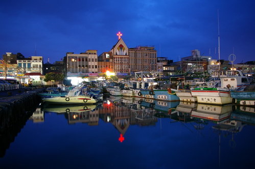
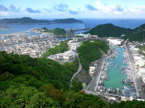
| 南方澳是東台灣最大的陸連島,與蘇澳港相通,地勢天成。外海的黑潮行經之處洄游魚類豐富,形成漁場。南方澳地區海岸地形景觀,主要為海岬、海岸岩礁、海蝕崖、海蝕洞、陸連島、海灣與沙灘。 南方澳附近海岸中的海岬、海岸岩礁、海蝕崖、海蝕洞、都是侵蝕作用形成屬於侵蝕型海岸,奇妙的海陸分布也同時出現沉積作用的地形,因為沙洲的前方有一個小島,所以形成屏蔽的效果,後方風浪不及之處堆積了大量的漂沙,形成連島沙洲。小島後方的沙洲將小島與陸地連接,形成陸連島,從山邊望去陸連島是一列小丘橫臥海上,海拔高度不到100公尺,在地形上有明顯的鞍部,尤其是右側三丘,宛如筆架,所以當地人稱之為「筆架山」。 Nanfangao is the largest isthmus along Taiwan’s western coastline. It is connected to Su-ao Harbor, with natural geographical layouts. The Black Tide that flows pass Nanfangao’s outer seas provides an abundance of migrating fish, forming natural fish grounds. The shoreline scenery of the Nanfangao region includes capes, reefs, cliffs, caves, isthmus, bays, and shores. The coastline along Nanfangao is classified as an erosion coast, so the appearance of a sandbanks is irregular. However, a small island acted as a barrier in the region, causing a sandbank to form from the large amounts of sand that settled behind the island. The sand dune connected with the mainland, forming an isthmus. From the mountains the isthmus is seen as a series of small dunes lying horizontally across the sea, with heights reaching no more than 100 meters. Saddle landforms are obvious, especially between the three dunes to the right, which together form the shape of a pen holder. Hence, the locals call this area “Pen Holder Mountain”. |
| 景點照片 | ||||
|

| 營業資訊 |
|
開放時間 全天開放 |
| 交通資訊 |
| 【大眾運輸】 1.火車 北迴線南方澳站下車。 2.客運 宜蘭、羅東、蘇澳火車站前搭國光客運往南方澳至南方澳下車。 【自行開車】 1.濱海公路-自基隆經台2線往頭城→冬山河→蘇澳→南方澳。 2.北宜公路-從台北經北宜公路(台9省道)至礁溪→宜蘭→羅東→冬山→蘇澳→南方澳。 |